Makalu: The Majestic Pyramid
A comprehensive exploration of the fifth-highest mountain on Earth, its formidable challenges, and its place in the Himalayan landscape.
Discover Makalu 👇 Climbing History 🧗Dive in with Flashcard Learning!
🎮 Play the Wiki2Web Clarity Challenge Game🎮
Makalu: An Overview
Summit Profile
Makalu stands as the fifth-highest mountain on Earth, with its summit reaching an impressive elevation of 8,485 meters (27,838 feet) above sea level. Its distinctive shape is that of an isolated, four-sided pyramid, presenting a formidable challenge to mountaineers.
Geographical Placement
Located within the Mahalangur Himalayas, Makalu straddles the border between Nepal and the Tibet Autonomous Region of China. It is situated approximately 19 kilometers (12 miles) southeast of Mount Everest, positioning it centrally within one of the world's most challenging and revered mountain ranges.
Classification
As one of the fourteen mountains exceeding 8,000 meters (the "eight-thousanders"), Makalu is recognized for its extreme altitude and technical difficulty. Its classification as an "Ultra-prominent peak" further underscores its significant topographic prominence.
Geographical Context
Himalayan Context
Makalu is part of the Mahalangur Himal section of the Himalayas. This range is renowned for hosting the planet's highest peaks, including Everest, Lhotse, Cho Oyu, and Kangchenjunga, creating a dramatic and awe-inspiring landscape.
Subsidiary Peaks
Makalu is distinguished by two significant subsidiary peaks that lie in its vicinity:
- Kangchungtse (Makalu II): Located approximately three kilometers to the north-northwest, this peak reaches an elevation of 7,678 meters (25,190 feet).
- Chomo Lonzo: Situated about five kilometers north-northeast across a broad plateau, Chomo Lonzo stands at 7,804 meters (25,604 feet). It is connected to Kangchungtse by a narrow saddle at 7,200 meters (23,600 feet).
Location Details
The mountain lies within Nepal's Koshi Province (Khumbu region) and China's Tibet Autonomous Region. Its precise coordinates are approximately 27°53′23″N 87°05′20″E.
Climbing History
Early Attempts and First Ascent
The initial attempts on Makalu were made in 1954 by American and New Zealand expeditions, facing severe weather and logistical challenges. A French reconnaissance expedition in the fall of 1954 successfully summited the subsidiary peaks, Kangchungtse and Chomo Lonzo. Makalu itself was first conquered on May 15, 1955, by French climbers Lionel Terray and Jean Couzy, via the north face and northeast ridge, establishing the standard route.
Notable Ascents
Makalu has witnessed numerous significant ascents, pushing the boundaries of mountaineering:
- 1970: First ascent of the Southeast Ridge by a Japanese team.
- 1971: The technically demanding West Pillar was first climbed by French mountaineers.
- 1975: The formidable South Face was ascended by a Slovenian expedition, marking a high-altitude face ascent without supplementary oxygen.
- 1981: Jerzy Kukuczka achieved a solo Alpine-style ascent via a new route on the northwest side, without oxygen.
- 1997: The challenging West Face was successfully climbed by a Russian expedition, earning a Piolet d'Or award.
- 2009: The first winter ascent was completed by Simone Moro (Italy) and Denis Urubko (Kazakhstan).
- 2022: Karl Egloff set a speed record, ascending in 17 hours and 18 minutes without support or oxygen.
- 2022: Adrian Ballinger achieved the first ski descent from near the summit.
Hazards and Challenges
Makalu is renowned for its steep pitches and exposed ridges, often subject to severe weather conditions. Its pyramid shape contributes to objective hazards like avalanches and rockfall, making it one of the more technically demanding eight-thousanders.
The Makalu-Barun Valley
Ecosystem and Location
The Makalu-Barun Valley is a significant glacial valley situated at the base of Makalu. This pristine region lies entirely within the Makalu Barun National Park in Nepal, serving as a gateway to the mountain's imposing massif.
Geological Significance
The valley showcases unique geological formations and diverse flora and fauna, characteristic of the high Himalayas. Its glacial origins have sculpted a landscape of dramatic cliffs, alpine meadows, and pristine rivers.
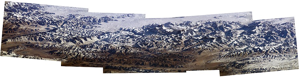
Perspectives from Above
Orbital Views
Makalu and its surrounding peaks, including Mount Everest, have been captured in stunning detail from the International Space Station. These orbital perspectives offer a unique vantage point, highlighting the vastness and interconnectedness of the Himalayan range.
A 2004 photo mosaic taken from the ISS provides an annotated view of the Himalayas, clearly showing Makalu and Everest. The image details various climbing routes and surrounding geographical features, offering a comprehensive visual context.
Ground-Level Perspectives
From base camps and surrounding viewpoints, Makalu presents itself as a striking pyramid. Images capture its steep faces, the glaciers that flow from its slopes, and its imposing presence against the vast Himalayan backdrop.
Visuals from the ground often depict Makalu's glaciers and its iconic pyramidal shape. These images emphasize the scale and isolation of the mountain, offering a climber's perspective of its challenging terrain.

Makalu from the southwest.

Glacier on Makalu.

Makalu's imposing profile.
Teacher's Corner
Edit and Print this course in the Wiki2Web Teacher Studio

Click here to open the "Makalu" Wiki2Web Studio curriculum kit
Use the free Wiki2web Studio to generate printable flashcards, worksheets, exams, and export your materials as a web page or an interactive game.
True or False?
Test Your Knowledge!
Gamer's Corner
Are you ready for the Wiki2Web Clarity Challenge?

Unlock the mystery image and prove your knowledge by earning trophies. This simple game is addictively fun and is a great way to learn!
Play now
References
References
- The elevation given in this article has depended upon source and when measured. The current sources used are recent and are generally accepted for heights in the area.
Feedback & Support
To report an issue with this page, or to find out ways to support the mission, please click here.
Disclaimer
Important Notice
This page was generated by an Artificial Intelligence and is intended for informational and educational purposes only. The content is based on a snapshot of publicly available data from Wikipedia and may not be entirely accurate, complete, or up-to-date.
This is not professional advice. The information provided on this website is not a substitute for professional geographical, geological, or mountaineering consultation. Always refer to official sources and consult with qualified professionals for specific needs related to high-altitude mountaineering or geographical data.
The creators of this page are not responsible for any errors or omissions, or for any actions taken based on the information provided herein.